Thursday, December 12, 2013

Sillustani

Sillustani Chullpa

Sillustani is on the peninsula of Umayo Atuncolla, it is nearby Puno, Peru. There is influence of Pukara (800 BC - 500AD) and influence of Qolla and Inca. These Chullpas were used as ceremonial towers, mostly for funerals or worship of the dead. The people of the town nearby bury there dead outside of town, using turret shaped tombs. Bodies were found in fetal position and mummified, not purposely mummified but the dry climate created the correct environment for mummification.

Chullpas being restored in Sillustani
"The Golden Sillustani" was so named when workers found 1280 objects of which 501 are gold. The pieces were different shapes and forms, with different techniques of decoration like embossing and drilling holes. 

There is a Lizard Chullpa that has a lizard carved on one side. The Chullpa is only partially built, either by design or it could be unfinished or destroyed by an earthquake. This Chullpa was built on the remains of Tiwanaku culture. 

Chullpa Igloo
Viceroy Toledo ordered all the graves removed from the ground and under to be moved and buried under the Chullpa. Apparently this was for all the people who died as heathens. The Chullpa Igloo is from the Late intermediate period.


Pukara


Pukara

Near Lake Titicaca's altiplano there was the ancient city of Pukara, it was a civic ceremony center approx. 400 BC. Pukara is known for its distinct pottery, with its different motifs of birds, llamas, felines, and humans. It is also known for the classic two bulls that you place onto of your finished house, this tradition of good luck and fertility is rumored to have started here.

House nearby Pukara ruins, bulls atop roof

Pukara's inhabitants were an organized city that engineered an irrigation system that would allow them to keep rainwater for longer and to tap into the water table moisture.

When the town of Pukara started expanding, and the church started to move in. The first move was to build a small chapel right onto of the Pukara ruins. This of course was not received well especially as time went on and people recognized the significance of their own heritage.

In Pukara human trophy heads were not unheard of and happened to be religiously significant. Human heads were a source of power, and also a trophy for good luck, fertility, abundant harvest and a sign of great prestige. Below is a carved stone that depicts a decapitated person, this is a common theme in art because of human sacrifices. This piece of art is supposed to give the impression of bravery and power.
Carved artwork in Museum


Saqsawaman

Saqsawaman


Saqsawaman

Located near Cusco, it has long been called the fortress with it's imposing zig zag wall it appears intimidating. In reality is was probably built for rituals or perhaps mock battles to celebrate. There is evidence of lots of store houses that were located on the open fields near by. There are three retaining walls that stretch at least 1300 ft. One of the walls contains mammoth carved boulders that look impossible to move without modern machinery. Even the Spaniards were impressed with this feat.

There was pottery found in nearby housing that suggests the that the workers were brought from the Lake Titikaka region.

The only time where this area was used as a fortress was during the Manco Pizarro siege. Manco was the Incan ruler that Pizarro actually appointed, once Manco realized that he could never actually rule under the spanish he started to recruit.

It is said that when Cuzco was built, it was designed in the shape of a Puma, in this scenario Saqsaywaman was the head and mane (zig zag).

Storehouse at Saqsawaman

Machu PIcchu


Machu Picchu
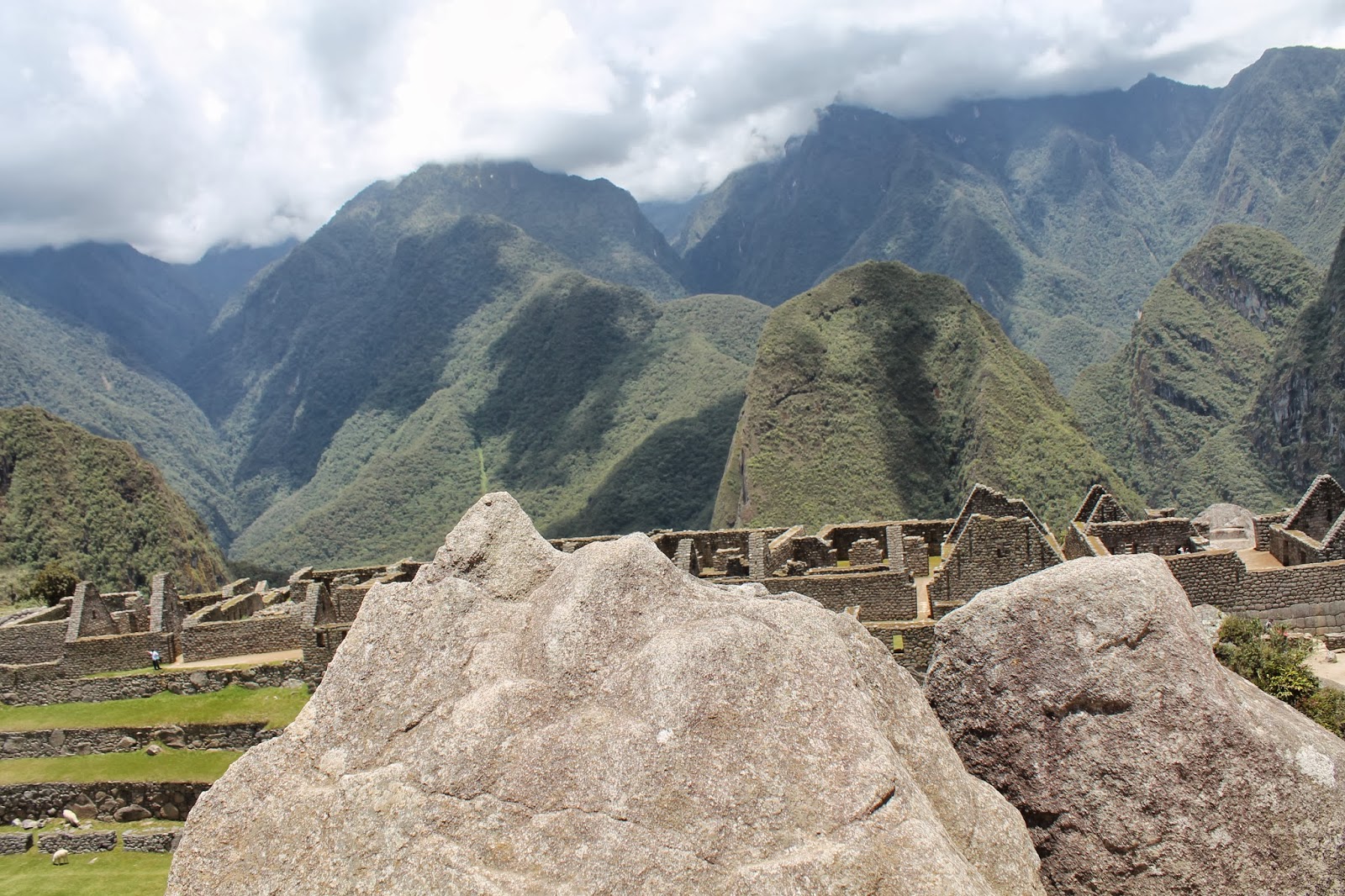
One of the seven wonders of the world, one of the most famous archaeological sights in South America. Machu Picchu is probably one of the greatest examples of Imperial style with a complete harmony for the geography. The picture shown below is a stone that was carved to mimic the mountain range behind it. It is estimated to have been built around 1450 AD.
Carved Rock in Machu Picchu

When Hiram Bingham brought Machu Picchu to attention around 1915 there were many theories that he proposed at to what Machu Picchu was used or built for. His main three theories were:
1) A place for the Chosen women or Sun Virgins to be trained for priestesses or brides for significant people.
2) Birthplace of the Incas
3) Historic town of Vilcambamba
Sadly as time went on and more researchers weighed in and looked at the evidence from not only the collection that Hiram Bingham collection, but at remains and likelihood of these theories became improbable. Currently archaeologists and researchers believe the Machu Picchu was a royal estate, that there was very little farming done despite the terraces surrounding it. It apparently was a place for drinking chicha (corn beer), there has been many vessels found for liquids. Dice have also been recovered and this suggests gaming, while metal balls that would have been sewn to clothes suggest dancing. This was a place relaxation and enjoyment - after its initial construction. 177 remains were found in graves around Machu Picchu, when examined there was a rich diet of corn which is considered a high status crop. This is an example of what indicates a royal estate. It is estimated that 750 people resided here, with few craftsmen among them. 
Machu Picchu looks to have been abandoned when the Spanish came, mostly because the city relied so heavily with the connection to Cuzco so when the Spaniards came and broke off that main connection inhabitants took there belongings and found new homes. 
Machu Picchu is home to some of the most iconic symbols of Incan architecture, with trapezoid windows, ingenious irrigation, use of natural rock formation and double jamed doorways. 
View from Machu Picchu

Friday, November 22, 2013

Ollantaytambo - Sacred Valley


Ollantaytambo
 Ollantaytambo was a hilltop fortress and temple. It was used as one of the last efforts to fend itself from the Spaniards. It was considered a fortress for its massive granite blocks and the fact that Manco Inca built the wall surrounding Ollantaytambo during the rebellion against the Spaniards in 1536.

There are still parts that look unfinished in Ollantaytambo, this could be because there was a remodel undergo when the Spanish invaded, possibly underway because of the Incan emperor Pachacuti. There still remains a ramp where the blocks are expected to have been dragged up from the nearby quarry. There are stones that do not have a "home, but this could also be to earthquakes, or the Spanish destroying certain parts of a building that cast the stones further from their original site.

An interesting aspect about Ollantaytambo is the storehouse that is directly across the valley that is visibly higher altitude, the higher altitude was to limit or prevent food decay. Like most agricultural terraces of the time there is extensive drainage and irrigation system throughout the terraces, this still holds today and prevents large amounts of erosion or flooding despite the modern changes in the town below.
View from Atop Ollantaytambo - View of Storehouse

While there is not much credible information that I have found about the actual inhabitants or interesting information on the habits of Ollantaytambo, there is a good deal of information or speculation about the construction and architecture. There is the double jammed doorway with such precise stonework that is mostly used in prestigious Inca buildings, this could indicate that Inca nobility or important people of the realm lived here at one point like an imperial estate, this site has been likened to Machu Picchu because of this possibility. There is also a half built Temple to Inti, that was thought to be been in process when the spaniards arrived. This leads archaeologists to believe that this area was used for ceremonies or even just a center for administrative purposes. In other words everybody seems to agree that this area was important for a variety of reason, and the evidence to support this is the beautiful stonework. Stones that fit together so closely, without the use of mortar and that have lasted for years and will continue to do so.
Solid Stone some weighing up to 50 tons

Sunday, November 3, 2013

Caral - The Lost Pyramids

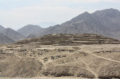
One of Caral Temple
Found in 1994 by Ruth Shady, Caral is estimated to be around 3000-2600 BC making it the oldest civilizations found in South America. Caral was an exciting find not only because it was relatively recent but because it could be the city that changes the idea of why civilizations were formed. There is a theory that modern society came from people bonding together for protection against fear and warfare.  Caral shows absolutely no evidence of conflict, warfare or weapons. Ruth Shady has given evidence that the reason people came together to make a community and city was for trade and religious purposes. It is thought of as the first central government that was created in South America


There is evidence of trade throughout Caral, there are remnants of fish; anchovies and sardines from the coast that is 32 km away. It appears to have been a good reciprocal trade from the coast, as Caral's crops consisted of cotton which was made into fishing nets. Crops also consisted of beans, squash, sweet potato, gourds, achira (queensland arrowroot), and guayaba fruit. There was an irrigation system from the river to the crops, the land in Supe is very fertile when water is available. Caral appeared to be a place where people enjoyed themselves, there is an amphitheater where many carved bone flutes were found, there was traces of a plant that was probably used as aphrodisiacs.  Hallucinogenics were found inside shells and could have been used during religious ceremonies, other drugs like coka plants, and lime plant which was inhaled as a substance. The only remains human remains found inside Caral was of a two month old baby, that was placed in a fetal position covered in fine cloth and beads which presumably came from a necklace or jewelry.  Another important find was a primitive looking khipu (quipu) which invalidates the suggestion that Wari culture created khipu's, this is especially significant because it means that it is one of the earliest forms or writing and record keeping.


Archaeologists have estimated that people inhabited Caral for around 1000 years, it was remodeled multiple times over this period. There are six temples which are all unique unto each other, with size, orientation and layout. This was probably to distinguish the temples to the residents and visitors. The temples are made earthquake resistant by having groups of the interior stones in nets, so movement could occur but would not dislodge the whole temple.  Near one of the temples, is a walled plaza with a sunken amphitheater, with elevated grounds around it. This is suggested to be symbolizing the mother east and the father apu, or some other balance in their world. Near the amphitheater (29 m in diameter) is a fire alter where religious ceremonies could have been centralized.


Vegetation around the river (view from near a temple)

Monday, October 21, 2013

Inca Empire Background


It is estimated that the Inca Empire was established 1200 AD and the demise of the Inca Empire in 1532 AD when Francisco Pizzaro desembarked near Tumbas, Peru. The Inca Empire (Tawantinsuyu) spread past  modern day Quito, Ecuador down to Santiago, Chile. The empire was separated into four quarters. Cuzco the capital and also the center point that connected the quarters Chichaysuyu, Antisuyu, Cuntisuyu, Collasuyu. The empire was made up of approx. 10 million Inca subjects, 40,000 people were actually considered Incas. Incas were the royal family and its descendants, while the rest were just viewed as Inca subjects.


Both the Wari (600 AD) and Tiwanaku (200 AD) were civilizations that help influence the Inca and decision making, they took from the Wari the idea of a network of roads that would interlace far flung cities, they also learned administrative techniques and the Khipu could possibly have come from the Wari culture, but this was discredited when a khipu was found at Caral. Tiwanaku was the first area out of Cuzco that the Incas conquered. This was a large gain for the Incas because of the source of income from the alpacas and llamas, used as a food source and used the fiber to make textiles.


Khipu's found at Pachacamac

Khipu's (literally translated as knot) pictured above were used as record keepers, it is assumed that they may have held information about the empires like tax data or agriculture gains/losses, or the movement of people and cities. The possibilities of what information they hold could be end less.  Khipu's as shown have a long length of chord (made out of cotton) with multiple cords attached, there were different sizes and colors. The knots themselves on khipu's could symbolize anything from numbers to words. There is two reasons that we do not fully understand or know how to read a khipu is that they are extraordinarily complex, and that there are only so many remaining. The few number of khipu's remaining - estimated 600 are, this may be because Pizarro was not interested in record keeping and did not bother preserving the khipu's or it could be that the spanish destroyed a large number of khipu's.


*Good website to visualize civilizations spread and change of cultures in South America. http://www.timemaps.com/history/peru-1500bc